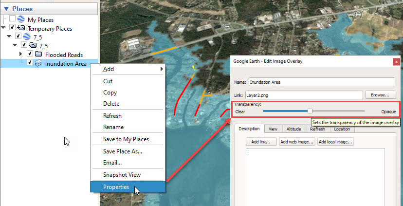
Google Earth files include grouped layers of flood inundation and flooded roadways. Layer transparency can be set in Google Earth as shown below. Care and judgement should be taken in the use of this data for emergency response, evacuations and road closures.
ACCEPT
Download KMZ Data
CANCEL
Close Downlaod Window
T-SAPP Disclamer
T-SAPP includes estimates of forecasted flood inundation and roadway impacts based on the Coastal Emergency Risks Assessment (CERA) storm surge, wave and compound flood guidance https://cera.coastalrisk.live. Forecasted surge estimates are obtained and processed for active Atlantic hurricanes and tropical storms. The inundation and roadway impacts shown do not reflect current flooding conditions. By entering this site, you accept that this data is for planning and informational purposes only.
WARNING: T-SAPP data should be considered “provisional”. Use and interpretation of T-SAPP data should be done by a professional trained in the development, application, and limitations of T-SAPP products.
ACCEPT
Access to surge data.
Welcome to T-SAPP
T-SAPP includes estimates of forecasted flood inundation and roadway impacts based on the ADCIRC Prediction System (APS).
Forecasted surge estimates are obtained and processed for active Atlantic hurricanes and tropical storms. The inundation and roadway impacts shown
do not reflect current flooding conditions. By entering this site, you accept that this data is for planning and informational purposes only
WARNING: T-SAPP data should be considered “provisional”. Use and interpretation of T-SAPP data should be done by a professional trained in the development, application, and limitations of T-SAPP products.
Enter Your NCID Credentials:
Note: NCID Authentication is disabled on our development server. Please login with the Username = "NCDOT" & Password = "NCDOT"
Enter T-SAPP
You have successfully
logged out of NC FIMAN.
You may continue using the site as a guest.
T-SAPP Contact:
NC Floodplain Mapping Program
4105 Reedy Creek Drive
Raleigh, NC 27607 Mailing Address
4218 Mail Service Center
Raleigh, NC 27699-4218 Phone:
(919) 715-5711 Fax:
(919) 715-0408 Send Email
Administrator Login
Authorized Users Only
Login Using Your NCID
Processing...
Please wait
There is no NexFim Data Available for this Time Period